One of the features that will be implemented on virtually every page of my book will be Site Summary Boxes. These helpful little boxes will span the foot of the page just beneath the citations and will help inform readers of the specifics of a location in a quick glance. Unlike the contents within the page, these will be uncited under the expectation that the information has already been cited within the article or in one of the introductory chapters. There are three different type of site summary boxes dealing with stations, trestles, and tunnels. All of this information, including samples, will be located in the methods section of the book near the beginning. Note: The header lines will not be in the finished book and are here for reference. They will also be added to article pages throughout SantaCruzTrains.com.
Universal to all boxes:
One of the primary reasons for these boxes is to allow aspiring researchers knowledge of the precise locations of stations, trestles, and tunnels. Thus there are sections that all three types of site summary boxes have in common:
- Location: This is the Southern Pacific mile-marker notation of the site’s location, sometimes with adjustments. The marker is based on the last available mile marker for that site and may have been adjusted to match the year of other mile markers (thus the mile markers for a site noted only in 1899 may be adjusted to match sites from 1923). The official mile marker notation will be posted in the article. For trestles, the location is based on the center of the trestle. For tunnels, the locations span the entire length of the tunnel, rounded up to the nearest tenth of a mile. When distances to or from a location are not posted in official documents, they are estimated using FreeMapTools.com’s Measure Distance on a Map tool (http://www.freemaptools.com/measure-distance.htm).
- Nearest Stops: This category is purely for reference and may anachronistically note neighboring stops that never existed simultaneously. That is because these references are as much a guide for the book as they are for geography. Distances for trestles are references from the center of the trestle while distances for tunnels are referenced from the nearest portal. Thus, the length of the tunnel is not taken into account but only the distance to the nearest portal.
- Coordinates: This feature is for those geocachers out there as well as your everyday hiker. These coordinates are based on estimates using iTouchMap.com‘s system of using Google Maps to find points (http://itouchmap.com/latlong.html). The coordinates are not 100% accurate but based on the best available estimate using the service and through my own research.
- Current Status & Ownership: Thinking about hiking that right-of-way? Think again. Some places really aren’t worth visiting while others may cause you more trouble than their worth. This section deals directly with the status of the site—as in what is still there—and the legality of accessing the site. And as a note, private property, when noted, means precisely that. Get permission from the owner before accessing the site.
Station Boxes:
The core component of the book will be stations, so naturally boxes dealing with stations are paramount. In addition to stations, sidings, spurs, freight stops, and other such locations will all fall under the station category for consistency purposes. The breakdown of the box is as follows:
- Established: This is the date that the station first was opened. If there are multiple names for the station, the dates for each named station will be listed (i.e., Lorenzo: 1885; Filbert: 1887).
- Service Ended: Since the majority of the stations along the route are now closed, this box notes the last year the regular service to the station ceased.
- Namesake: Stations have names, but the origins of those names are sometimes shrouded in mystery. Here is posted the most likely namesake for a station’s name. If a name’s origin is in doubt, the box refers the reader to the article for more information.
- Structures & Facilities: A station requires little more than a sign to designate it as such, and here posted are the myriad things that made each stop worthy of note.

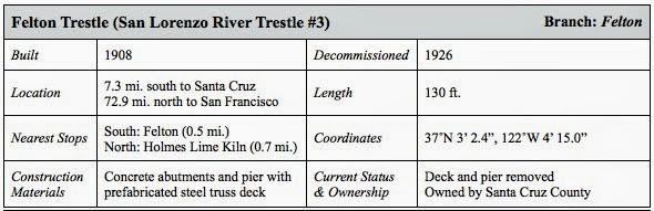
Trestle Boxes:
There are a lot of trestles that once spanned the Santa Cruz Mountains’ various rivers and streams. Most are now gone, though many have left pieces behind. These site summary boxes are here to help readers find and explore the history of these locations.
- Built: Every trestle had to be built, and this is where the date of that construction will be noted. If the trestle was replaced, it will be noted here as well.
- Decommissioned: Sadly, few trestles remain in the Santa Cruz Mountains. Here you will find the date that the trestle went out of use (though the precise date of its demolition is not always known).
- Length: Trestles could be very short or very long. For whatever reason, the Southern Pacific rarely noted the length of a trestle, but by using FreeMapTools.com’s Measure Distance on a Map tool (http://www.freemaptools.com/measure-distance.htm), the lengths of most trestles can be determined pretty accurately. (Note: A metric measurement should accompany the foot measurement on the example below.)
- Construction Materials: Was the trestle made of wood or steel? Was the steel a custom build or a prefabricated design? Were any piers required to hold the trestle up? These answers and more can be found in this box.
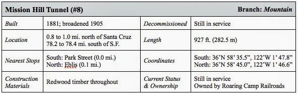
Tunnel Boxes:
At one time, there were eight tunnels that ran through the Santa Cruz Mountains. A ninth was anticipated but collapsed during construction while a large one to Pescadero was planned but never was built. Each has its own set of interesting facts to necessitate site summary boxes:
- Built and Decommissioned: Just like with trestles, tunnels had to have been built and all but one of them are now decommissioned. Look here for the dates of those important events, as well as the dates for any significant expansions to the tunnel.
- Length: Unlike trestle lengths, the Southern Pacific kept good records of their tunnels and the lengths of all eight of them are known. Check here to see the length of the tunnel in feet and meters.
- Construction Materials: Tunnels were made of a variety of materials but generally wood, brick, and concrete. Check here to see what materials comprised each tunnel.
That sums up the site summary boxes. They are all in production currently and will roll out across the blog over the next few weeks. If you feel like an important fact set is missing from these boxes or something is really unnecessary, feel free to note it in the comments below or email me. As usual, all suggestions will be considered. Thank you!